Flight Map FREE -
Own personal flight tracker, speed and altitude while flying in the air
YOU CAN DO IT ON A PLANE!
هناك خريطة طيران من إصدار مدفوعة ، تتضمن قاعدة بيانات للمطارات العالمية ، ووقت وصول وتسجيل المسار الذي يمكن مشاركته على الشبكات الاجتماعية ، لذلك بعد أن جربت Flight Map FREE ، قد تفكر في الترقية. Or, you might consider upgrading to Flight Map HD, which has much more detailed map of the world.
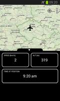
Flight Map FREE is a unique application that works as your own personal flight tracker (Sky map) while flying in an airplane. It shows where you currently are, speed, altitude and some other information about your flight. You can also see and name the landmarks on the way, so that you know what you see from your window.
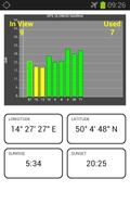
Flight Map FREE also displays visible and used GPS / GLONASS satellites, so you can use it as a GPS testing tool. تعمل وظيفة GPS عندما يكون هاتفك في وضع الطائرة ، لأنه لا يبث أي راديو ، فهو يستمع إلى أقمار GPS فقط.
تشمل الميزات:
- Real time position of the plane on the map
- Zoomable world map not dependent on a connection to internet
- Your own personal flight tracker
- Works when your phone is in Airplane mode, so it can be used anytime while in flight
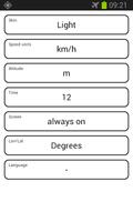
- Dark / Light skin
- Metric / Imperial units
- Multilanguage (currently English, Spanish, Portugese, French, Russian, Chinese, Vietnamese, Czech, Japanese, Korean, Polish, Hungarian)
- Map can be fullscreen or split screen with real time flight data
- GPS / GLONASS Satellites real time display depending on your device capabilities
- Sunrise and sunset at present position
Please note that Flight Map FREE is heavily dependent on the quality of your device's GPS capabilities. إذا كان جهازك قادرًا على A-GPS (GPS بمساعدة) ، فيرجى تشغيل التطبيق أثناء وجوده على الأرض ، بحيث يتم تنزيل مواقع الأقمار الصناعية من الإنترنت ، فسيكون من الأسهل على الجهاز التقاط الإشارة عندما تكون في الهواء.
Please share your experience with various devices. تعمل Flight Map FREE في معظم الوقت بشكل مثالي عند الجلوس في مقعد النافذة ولا تعمل بشكل جيد للغاية عند الجلوس مقعدين من النافذة أو أكثر. في أي حال ، نوصي بنقل الجهاز إلى النافذة ، دعه يلتقط إشارة الأقمار الصناعية أولاً ثم جرب مدى المسافة التي يمكنها التقاط الإشارة. The screen showing the visible and used satellites is designed to help you with this.
If your device is capable of receiving GLONASS signal, the satellites are shown with a differently colored border. If you want to translate Flight Map FREE into your language (or correct our translation), please contact the developer. The first run of the application takes a while because it needs to unpack the whole world map to be able to display it.
Polish translation thanks to Tomasz Pryca
Hungarian translation thanks to Dr. Istvan Lunczer