YamaNavi -
YamaNavi is software that displays a map that you created in Kashmir 3D mobile. I quite useful in the mountains out of reach of radio waves.
YamaNavi is a software that displays maps created in Kashmir 3D on your mobile phone.
[How to deal with the issue where the old version of the track logs become invisible in version 4.2]
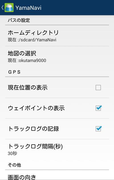
□In Android 4.4, track logs cannot be written to SD cards, and since it is written to internal memory, you can no longer view track logs recorded in the previous version.
□As a way to deal with this, you can display the track logs recorded in the previous version by moving them to internal memory.
□You can find out where it is stored in the internal memory using the following method
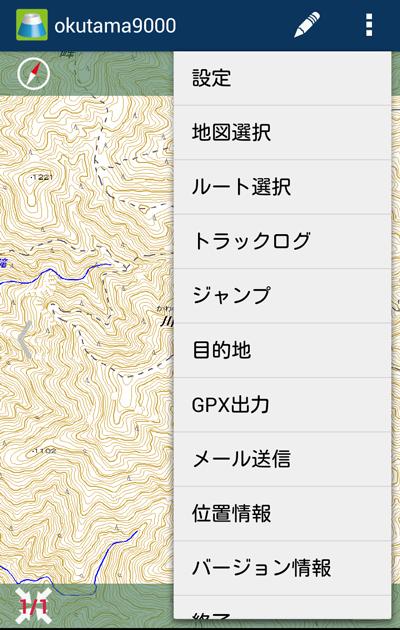
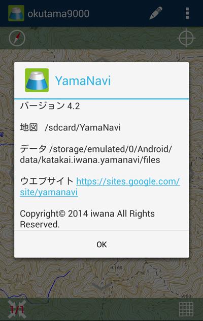
Click on version information from the menu on the top right
The path location shown in the row "Data" is the folder where the new track log is recorded.
The "xxxxxxx.bin" file at the path location shown in the line "map" is the data in the track log.
However, xxxxxx is the date of the format yyyymmdd
□ To move files, please either from your PC or use an Android app that allows you to move files.
[Main features]
-Can be used even outside the communication range.
・Your current location is displayed on the map using GPS.
- Set your destination to display the distance and direction from your current location.
- You can leave track logs.
- You can zoom in and out of the map.
- You can display the compass on the map.
*From this version (3.7), it cannot be used on Android 1.6 devices.
We are sorry, but we have released YamaNavi 16 so please use that.
What's New in the Latest Version 4.2
Last updated on Mar 23, 2016 [Version 4.2 update information]- Compatible with OS4.4.
- Track logs can now be recorded.
- YamaNavi has moved the write location to a different location from the map.
-The screen design has been changed.
-Action bar has been adopted -Buttons are visible --Compass, current location, and map reduction/enlarge, return, grid, right, left, top, bottom ・File deletion function has been added ・Unwanted items have been deleted from settings ・There are two types of files that can be sent by email -gpx file (track log)
-txt file (note information)
Note: From this version 4.2, files such as track logs and memo information written by YamaNavi will be deleted when you uninstall YamaNavi , so if necessary, please move them in advance or send an email.
[Version 4.1 update information]
・Yamareco GPX files can now be used as YamaNavi route data ・No limit has been changed from 500 points limit for route points